


 |
 |
 |
 |
 |
 |
This map shows US Census Bureaus Census Tracts. The map also shows individual Block Groups within a census tract. If you know your Census Tract and Block Group numbers, then it is possible to look up census data on just your track or block group. Note that there are differences between the census tracts for the 1990 census and the 2000 census.
|
You can find maps and other information at the US Census Bureaus American Fact Finder web site. Enter your tract number on www.freedemographics.com for out free demographic reports. |
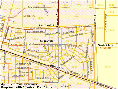 |
To be more exacting, you can use Block Group numbers to further specify a census area. Using Block Groups helps eliminate populations that are outside of Lakewood Village from the census data. For the 2000 census, here are the tract and block group numbers:
- Unit 1: Census Tract 5048.02, Block Group 3 (includes also The Arches apartment complex)
- Unit 2: Census Tract 5048.06, Block Group 2
- Unit 3: Census Tract 5048.02, Block Group 2
- Unit 4: Census Tract 5048.06, Block Group 1
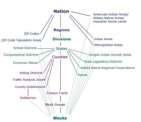
It is also possible to get all the way down to individual Blocks.
The diagram, below, shows how Census Tracts and Block Groups fit into the overall scheme of census geography.
 |
For additional information, including the 1990 Census Tract and Block Group numbers, go to the Census page. For summary census and other data, see the neighborhood profiles in each of the decade pages in the History section.


[Lakewood Village] [The LVNA Villager] [Events and Activities] [The LVNA] [Resources]
|
Copyright ©2002-2008 Brian Smithson |