


 |
 |
 |
 |
 |
 |
Census Source Data
1990 and 2000 Census Data at Block Group level
US Census Bureau data for 1990 and 2000 is available down to the block group level within a census tract (see the Census Tract Map for definitions). Block groups in the Lakewood Village area correspond to Lakewood Villages units, with one exception: the block group that contains Unit 1 also contains The Arches apartment complex, and the presence of those apartment dwellers in the data set significantly alters the size and makeup of the population in that area. For that reason, I have charted only units 2, 3, and 4.
Data for 1990 is more complete than for 2000 because the only data available for California from the 2000 census are the SF1 and SF2 data sets. These data sets are primarily demographic. Economic data in the 2000 SF3 data set has not yet been released for all of the states. As soon as SF3 data is available, Ill update this site.
The complete data is available in a large Excel spreadsheet that presents data for the individual block groups, totals with and without unit 1, and comparison data for the city of Sunnyvale as a whole. Data is provided for 1990 and 2000, and for 1990 compared to 2000. You can obtain the raw data from the US Census Bureau at their FactFinder web site.
1970, 1980, and 1990 Census Data for 1990 Census Tracts 5048.02 and 5048.04
Older US Census Bureau data is available for an area bounded by Calabazas Creek to the east, CA Route 237 to the north, Fair Oaks Avenue to the west, and US Highway 101 to the south. In other words, it covers Lakewood Village, The Arches apartment complex, the mobile home parks to the north and east, and the light industrial area to the north. The data from which this table was extracted is available in an Excel spreadsheet. It was obtained from FreeDemographics.com and has comparative data for 1970, 1980, and 1990.
Census Tracts and Block Groups
2000 Census
- Unit 1: Census Tract 5048.02, Block Group 3 (includes The Arches apartment complex)
- Unit 2: Census Tract 5048.06, Block Group 2
- Unit 3: Census Tract 5048.02, Block Group 2
- Unit 4: Census Tract 5048.06, Block Group 1
1990 Census
- Unit 1: Census Tract 5048.02. Block Group 3 (includes The Arches apartment complex)
- Unit 2: Census Tract 5048.04, Block Group 5
- Unit 3: Census Tract 5048.02, Block Group 2
- Unit 4: Census Tract 5048.04, Block Group 3
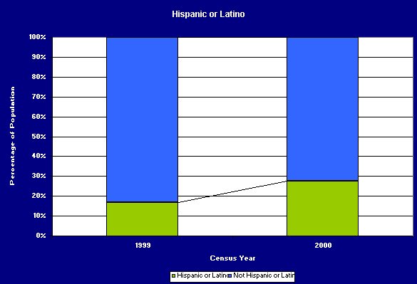
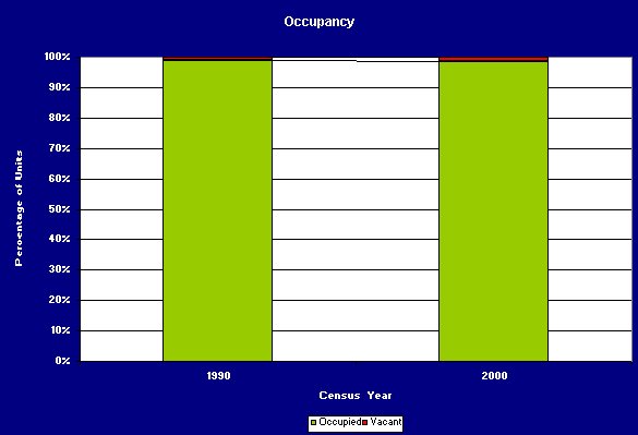
Census Trends in 1990 and 2000
The following charts are comparisons of the US Census Bureau data for 1999 and 2000. Data is available down to the block group level within a census tract (see the Census Tract Map for definitions). Block groups in the Lakewood Village area correspond nicely with Lakewood Villages units, with one exception: the block group that contains Unit 1 also contains The Arches apartment complex, and the presence of those apartment dwellers in the data set significantly alters the size and makeup of the population in that area. For that reason, I have charted only units 2, 3, and 4.
People


Housing Units


The complete data from which these charts were derived is available in a large Excel spreadsheet. This spreadsheet has data for the individual block groups, totals with and without unit 1, and comparison data for the city of Sunnyvale as a whole, for census years 1990 and 2000, plus a comparison of those two census years. Each of the charts shown here is also in the spreadsheet..
Or, if you prefer, you can obtain the raw data from the US Census Bureau at their FactFinder web site.
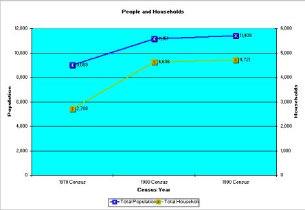
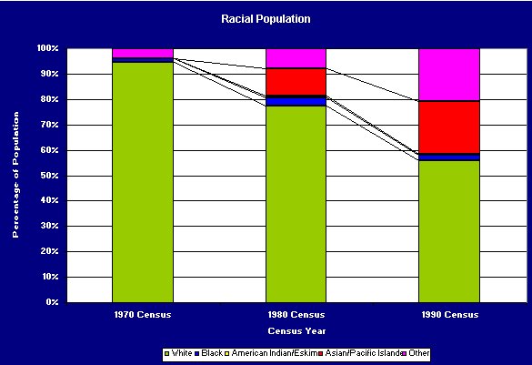
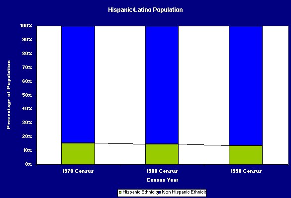
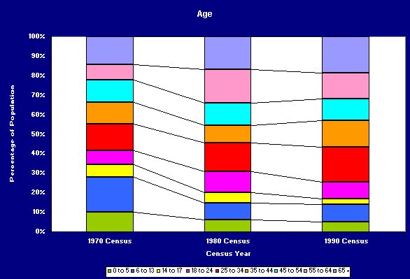
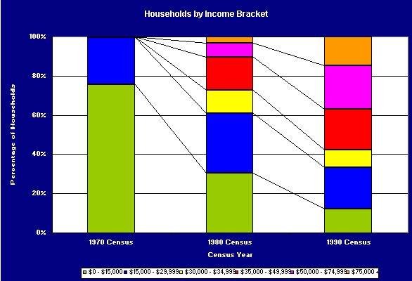
Census Trends in 1970, 1980, and 1990
This data is from a US Census Bureau data set which represents the area bounded by Calabazas Creek to the east, CA Route 237 to the north, Fair Oaks Avenue to the west, and US Highway 101 to the south. In other words, it covers Lakewood Village, the Arches apartments, the mobile home parks to the north and east, and the light industrial area to the north. It was obtained from FreeDemographics.com.


[Lakewood Village] [The LVNA Villager] [Events and Activities] [The LVNA] [Resources]
|
Copyright ©2002-2008 Brian Smithson |